MAP TEMSI
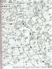
It's a map describing a meteorological situation for aeronautics. It is distributed every 3 hours.
Features of a typical map are the hour of validity (1), the center of pressure
(H) for anticyclone and (L) for depression (2), the position of fronts
(3), the limit of significant time (4), phenomena with
particular symbol (5) (chart for examples), the turbulence (6),
the level of the isotherm zero (7), temperature
and level of the tropopause (8).
| CAT: Clear Air Turbulence | |
(numbers are on the maps)
 |
 Home Page |